| Water Resource Report 56 |
 | Groundwater resources of the West Branch Susquehanna River basin, PennsylvaniabyTaylor, L. E., Werkheiser, W. H., and Kriz, M. L.1983 |
| Suggested Citation: | Taylor, L. E., Werkheiser, W. H., and Kriz, M. L., 1983, Groundwater resources of the West Branch Susquehanna River basin, Pennsylvania: Pennsylvania Geological Survey, 4th ser., Water Resource Report 56, 143 p. [Available online.] |
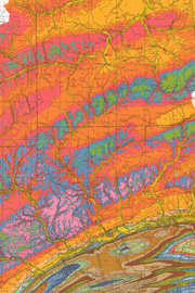
| Description: | A groundwater study of the West Branch Susquehanna River basin, an area of 7,280 square miles in north-central Pennsylvania, is the subject of this report. The study area is one of abundant water resources, a result of high precipitation. Most of the area is in the Appalachian Plateaus province, but some of the southern part is in the Ridge and Valley. The basin is underlain by sedimentary rocks (Cambrian through Pennsylvanian), and thick deposits of glacial till cover parts of the northeast region. Major text topics are hydrology, hydrogeology, groundwater quality, stratigraphy and water-bearing properties of the rocks, and management of water supplies. Tables include data on water use, summaries of well statistics and water measurements, records of wells and springs, and chemical analyses of groundwater. There is a plate with a 1:250,000-scale geologic map, showing the locations of wells, springs, and significant alluvium deposits. The map explanation describes each geologic unit and its associated well yields and water quality. Also on the plate is a small-scale map illustrating the median hardness of groundwater. |
| Download Publication: | Click Here (27 MB) |