| Water Resource Report 50 |
 | Groundwater and geology of the Cumberland Valley, Cumberland County, PennsylvaniabyBecher, A. E., and Root, S. I.1981 |
| Suggested Citation: | Becher, A. E., and Root, S. I., 1981, Groundwater and geology of the Cumberland Valley, Cumberland County, Pennsylvania: Pennsylvania Geological Survey, 4th ser., Water Resource Report 50, 95 p. [Available online.] |
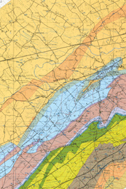
| Description: | This is a detailed report (text and three plates) on the geology and groundwater resources of the northeastern part of the Cumberland Valley where it occurs in Cumberland County—a structurally complex area that is underlain by sedimentary rocks of Cambrian and Ordovician age and one Mesozoic diabase dike. Text topics include geologic setting, hydrologic system, water-yielding properties of the rock units, effect of geologic structures on hydrology, effect of topography on well yields, groundwater quality, and problems caused by flooding, bacterial contamination, and a gasoline spill. An appendix gives an excellent overview of the regional geology and detailed descriptions of the stratigraphy (including where to find good exposures). Data in fourteen tables (including chemical and bacterial analyses, and records of wells and springs) complement the text discussion. Plate 1 is a 1:50,000-scale bedrock geologic map, on which the locations of wells and springs are shown. Plates 2 and 3 are smaller scale maps. Plate 2 shows the change in groundwater levels between March and November 1972 in the carbonate rocks, and Plate 3 shows the distribution of specific conductance of groundwater in the area. |
| Download Publication: | Click Here (40 MB) |