| Water Resource Report 48 |
 | Summary groundwater resources of Centre County, PennsylvaniabyWood, C. R.1980 |
| Suggested Citation: | Wood, C. R., 1980, Summary groundwater resources of Centre County, Pennsylvania: Pennsylvania Geological Survey, 4th ser., Water Resource Report 48, 60 p. [Available online.] |
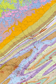
| Description: | This report is a comprehensive description and inventory of the groundwater resources in Centre County. It consists of a text and one plate. The area represents two physiographic provinces: the Appalachian Plateaus in the northwest one third, and the Ridge and Valley in the southeast two thirds. Many sedimentary rock formations ranging from Cambrian through Pennsylvanian in age are exposed in the report area. The text covers the hydrologic cycle, gives a description of the rock units and their water-bearing characteristics, and discusses the factors affecting well yields in the county, the development of groundwater supplies, water problems resulting from man’s activities, and well construction. Data are presented in seven tables and include records of wells and springs, and chemical analyses of groundwater. The plate shows a 1:100,000-scale geologic map of the county that includes faults and the locations of wells, springs, and stream-gaging stations. The map explanation describes the geologic units shown and their aquifer characteristics. |
| Download Publication: | Click Here (16 MB) |