| Water Resource Report 43 |
 | Summary ground-water resources of Lancaster County, PennsylvaniabyPoth, C. W.1977 |
| Suggested Citation: | Poth, C. W., 1977, Summary ground-water resources of Lancaster County, Pennsylvania: Pennsylvania Geological Survey, 4th ser., Water Resource Report 43, 80 p. [Available online.] |
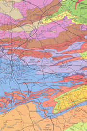
| Description: | This report discusses various groundwater-related issues in Lancaster County, including the bedrock formations and their groundwater properties, well yields, public water supplies, well construction, and well development. It has a 1:125,000-scale geologic map that shows the locations of wells and springs, a record of wells, a record of springs, and a table of chemical analyses of groundwater. Rock units in the area include diabase, Gettysburg-Hammercreek Formation, New Oxford-Stockton Formation, Cocalico Formation, Conestoga Formation, Beekmantown Group, Conococheague Group, Elbrook-Zooks Corner Formation, Ledger Formation, Kinzers Formation, Vintage Formation, Antietam and Harpers Formations (undivided), Chickies Formation, Peter Creek Schist (includes Peach Bottom Slate), Wissahickon Formation, serpentinite, and undifferentiated metamorphic and igneous rocks. |
| Download Publication: | Click Here (13 MB) |